Updated 30 m resolution global annual burned area map
30 m resolution global annual burned area maps (GABAM) of 1985-2021 are released for free download.
Description
The annual burned area map is defined as spatial extent of fires that occurs within a whole year and not of fires that occurred in previous years.
GABAM was generated via an automated pipeline based on Google Earth Engine (GEE), using all the available Landsat images on GEE platform. The product was projected in a Geographic (Lat/Long) projection at 0.00025° (approximately 30 meters) resolution, with the WGS84 horizontal datum and the EGM96 vertical datum, consisting of 10°×10° tiles spanning the range 180°W–180°E and 80°N–60°S.
The following figure illustrates the global distribution of burned area (BA) density from GABAM 2015, which is defined as the proportion of burned pixels in a 0.25°×0.25° grid.
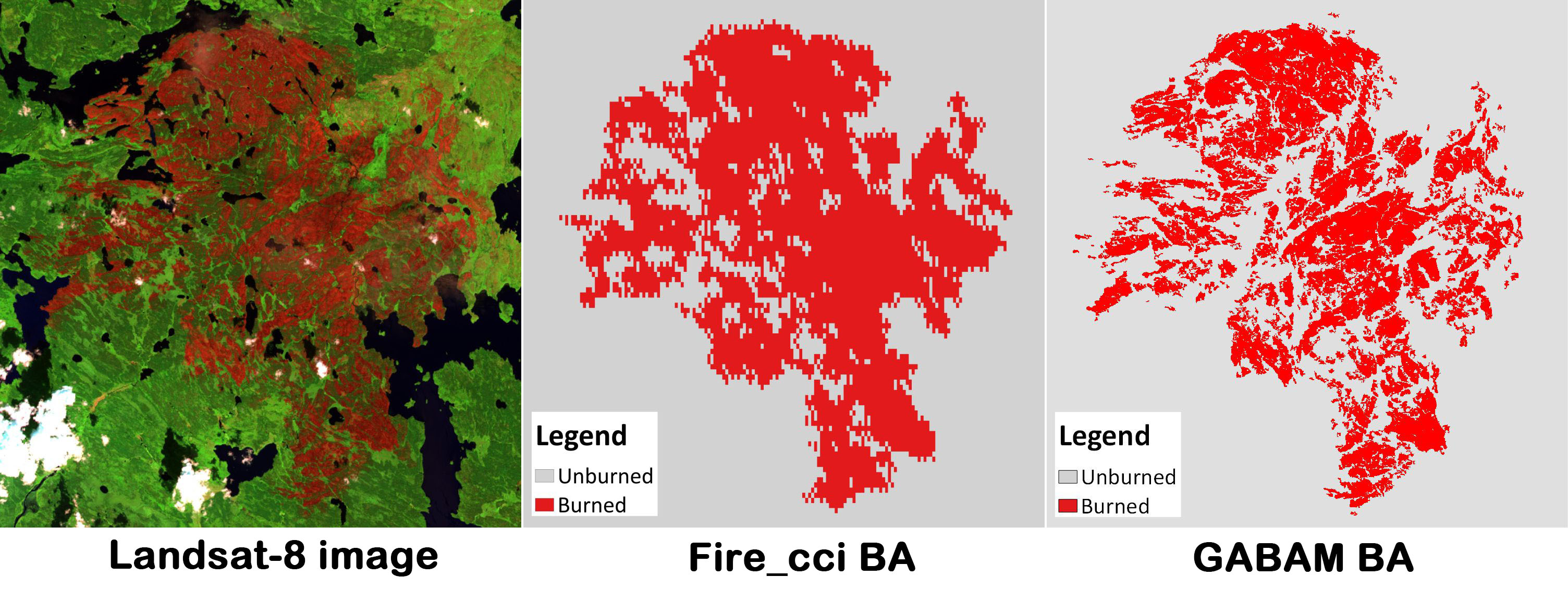
Comparison with the recent Fire_cci version 5.01 global BA product of 250 m resolution (highest spatial resolution before GABAM):
Download
GABAM can be downloaded from ftp server1, ftp server2 or Zenodo.
It is recommended to use FTP clients, such as Filezilla, to download data from FTP servers.
Citation
To use this dataset, please cite the following paper.
@article{Long_2019,
doi = {10.3390/rs11050489},
url = {https://doi.org/10.3390%2Frs11050489},
year = 2019,
month = {feb},
publisher = {{MDPI} {AG}},
volume = {11},
number = {5},
pages = {489},
author = {Tengfei Long and Zhaoming Zhang and Guojin He and Weili Jiao and Chao Tang and Bingfang Wu and Xiaomei Zhang and Guizhou Wang and Ranyu Yin},
title = {30 m Resolution Global Annual Burned Area Mapping Based on Landsat Images and Google Earth Engine},
journal = {Remote Sensing}
}
Please feel free to contact us (longtf@radi.ac.cn), feedback is welcome!
-
Chuvieco, E., Lizundia-Loiola, J., Pettinari, M.L., Ramo, R., Padilla, M., Tansey, K., Mouillot, F., Laurent, P., Storm, T., Heil, A., & Plummer, S. (2018). Generation and analysis of a new global burned area product based on MODIS 250 m reflectance bands and thermal anomalies. Earth Systems Science Data, 10, 2015-2031. ↩︎